-
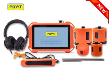
Brand: PQWTPQWT–L7000Request Quote
Product Features:
Measurement Area: Indoor or outdoor underground and walls pipeline leakage detection.
Sensor: Large Sensor, Middle Sensor, Triangular Sensor, Square Sensor
Detection Depth: Large Sensor&Middle Sensor: 5m (195 inch); Triangular Sensor&Square Sensor: 50cm (20 inch)
Headphones: High Frequency Noise Canceling Headphones
Application: Indoor and Outdoor Underground Pipes
Working Principle: By collecting and analyzing the leakage signal, pinpointing the leakage on the pressure pipelines. -
Brand: PQWTPQWT-125ARequest Quote
Product Features:
• Brand Name: PQWT
• Detection function: indoor
• Measurement and measurement: 0.5m
• Positioning range: ± 0.25m
• Detection modes: general mode, position mode
• Warranty: 2 years
• Origin: China -
Brand: PQWTPQWT-125BRequest Quote
Product Features:
• Brand Name: PQWT
• Detection function: Outdoor
• Measurement and measurement: 3m
• Positioning range: ± 1m
• Detection modes: census mode, positioning mode
• Warranty: 2 years
• Origin: China -
Brand: PQWTPQWT-125CRequest Quote
Product Features:
• Brand Name: PQWT
• Detection function: indoor/Outdoor
• Measurement and measurement: 3m
• Positioning range: ± 1m
• Detection modes: census mode, positioning mode
• Warranty: 2 years
• Origin: , China -
Brand: PQWTPQWT-GT150A Original price was: KShs 7.00.KShs 5.00Current price is: KShs 5.00.Add to cart
Product Features:
- Automatic analysis: The instrument analyzes the abnormal area with one click.
- Automatic mapping: Automatically draw curve map, profile map, and 3D renderings.
- Stable and reliable: Collect 18 points data with one-time wiring.
- Increment function: The extension of geological structure can be analyzed by making supplementary measurement in front and rear of the survey line.
- Data storage: It can store curve map, profile map, and 3D renderings of more than 999 survey lines to facilitate the production of geophysical exploration reports.
-
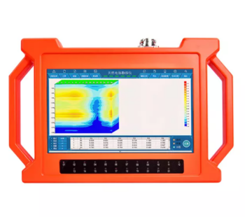
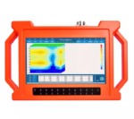
Brand: PQWTPQWT-GT300A KShs 399,167.60Add to cart
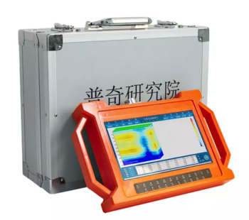
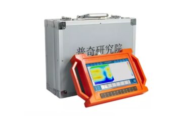
PQWT-GT Auto-analysis Geophysical Detector is the eighth generation of multi-channel prospecting instrument newly developed by Hunan Puqi Geologic Exploration Equipment Institute and Hunan Puqi Water Environment Institute Co. Ltd.; it is based on the principle of natural electric field frequency selection method. It is widely used in underground water sources, geological structures, mine veins, mine tunnels, cavities, karst caves, ant holes, mined-out areas, dam pipe surge, landslides and other fields. This series of instruments integrates 5 independent invention patents of PQWT, including data acquisition system, data processing system, automatic mapping system, automatic analysis system and circuit system. It realizes the simultaneous data acquisition of multi-channel and multi-frequency, completely solves the influence of unstable factors caused by the time difference of the natural electric field source, and greatly improves the accuracy and work efficiency. The instrument can process the collected data, automatically draw curve map, profile map, and 3D renderings in real time, and automatically analyze abnormal areas, to provide scientific basis for analyzing geological structures quickly and effectively.
Product Features:
- Automatic analysis: The instrument analyzes the abnormal area with one click.
- Automatic mapping: Automatically draw curve map, profile map, and 3D renderings.
- Stable and reliable: Collect 18 points data with one-time wiring.
- Increment function: The extension of geological structure can be analyzed by making supplementary measurement in front and rear of the survey line.
- Data storage: It can store curve map, profile map, and 3D renderings of more than 999 survey lines to facilitate the production of geophysical exploration reports.
-
Brand: PQWTPQWT-GT500A KShs 463,797.00Add to cart
The PQWT-GT Auto-Analysis Geophysical Detector is an advanced 8th-generation multi-channel groundwater and geological exploration instrument developed by Hunan Puqi Geologic Exploration Equipment Institute.
Using the natural electric field frequency selection method, it enables precise detection of underground water, mineral veins, geological structures, tunnels, cavities, and landslides.
it is equipped with five patented technologies for automatic analysis, mapping, and real-time 3D visualization, delivering accurate, efficient data collection and interpretation.
It supports multi-channel, multi-frequency measurement, eliminating time-difference errors and stores over 999 survey results, making it ideal for geophysical surveys, hydrogeological studies, and environmental engineering application.Depth: 100m/150m/300m/500m
Measuring time: 8-10min
Measurement data unit electric field component of different frequencies of the earth electromagnetic field ΔVs (mV)
Maximum Channels: 18 channels
Display Screen: Industrial 10.1-inch HD touch screen.
A/D conversion: 16-bits 1Msps
Minimum resolution: 0.001mv
Point selection: 1-18 points optional.
Power consumption: about 9W
Working environment temperature: -20°C ~ +50°C
Controller: 32-bit high speed CPU
Standby time: 8h
Cable: 2.5m point pitch, 10m line pitch 54.7m in total length
Electrode: Each comes standard with 22pcs
Host Weight: 1.95kg -
Brand: PQWTPQWT-L2000Request Quote
Product Features:
Brand Name: PQWT
Measuring Area: Outdoor
Sensor: Middle
Operating Mode: General Detection; Operating Mode -
Brand: PQWTPQWT-L3000Request Quote
Product Features:
• Brand Name: PQWT
• Measuring area: Indoor and Outdoor Pipeline
• Sensor: Medium + Horizontal sensor
• Measurement depth: 5m
• Detection modes: census mode, positioning mode
• Warranty: 2 years
• Origin: China -
Brand: PQWTPQWT-L4000Request Quote
Product Features:
• Brand Name: PQWT
• Measuring area: Indoor and Outdoor Pipeline
• Sensor: Medium + vertical sensor
• Measurement depth: 5m
• Detection modes: census mode, positioning mode
• Warranty: 2 years
• Origin: China -
Brand: PQWTPQWT-L5000Request Quote
Product Features:
• Brand name: PQWT
• Measuring area: indoor and outdoor pipes
• Sensor: Medium+ vertical +horizontal sensor
• Measurement depth: 5m
• Detection modes: census mode, positioning mode
• Warranty: 2 years
• Origin: Changsha, Hunan, China -
Brand: PQWTPQWT-L6000Request Quote
Product Features:
Measurement Area: Indoor or outdoor underground pipes leakage detection.
Sensor: Large Sensor, Middle Sensor
Detection Depth: Large Sensor&Middle Sensor: 5m (195 inch)
Headphones: High Frequency Noise Canceling Headphones
Application: Indoor and Outdoor Underground Pipes
Working Principle: By collecting and analyzing the leakage signal, pinpointing the leakage on the pressure pipelines. -
Brand: PQWTPQWT-M100 KShs 106,744.36Add to cart
PQWT-M100.100M mobile water detector is based on the Earth’s electromagnetic field as the field source, based on the difference in the conductivity of different underground geological structures, and by studying the variation law of the electric field components at different frequencies to study the geological structure and changes, to find groundwater resources by scientific method. Changes in geological structure are displayed in real-time through multiple curves. Automatic form mapping geological profile by one key operate easily, get rid of complicated computer graphics. The site can quickly understand the geological structure through the automatic mapping curve and profile, and analyze specific information such as aquifers, fractures, faults, and caves. The instrument is widely used in the rapid analysis of geological structure changes in different terrains such as plains, hills, mountains, plateaus, and basins to determine well locations, aquifers, and aquifer depth.
- No need to register
- No need network, no need traffic
- Automatically draw geological profile map
- Suitable for various terrain exploration
- Expert remote assistance to find location
- No experience person can operate in 5 minutes
- Two years warranty.
-
Brand: PQWTPQWT-M400 KShs 128,287.88Add to cart
PQWT-M400.400M mobile water detector is based on the Earth’s electromagnetic field as the field source, based on the difference in the conductivity of different underground geological structures, and by studying the variation law of the electric field components at different frequencies to study the geological structure and changes, to find groundwater resources by scientific method. Changes in geological structure are displayed in real-time through multiple curves. Automatic form mapping geological profile by one key operate easily, get rid of complicated computer graphics. The site can quickly understand the geological structure through the automatic mapping curve and profile, and analyze specific information such as aquifers, fractures, faults, and caves. The instrument is widely used in the rapid analysis of geological structure changes in different terrains such as plains, hills, mountains, plateaus, and basins to determine well locations, aquifers, and aquifer depth.
Product Features:
- No need to register
- No need network, no need traffic
- Automatically draw geological profile map
- Suitable for various terrain exploration
- Expert remote assistance to find location
- No experience person can operate in 5 minutes
- Two years warranty.
-
Brand: PQWTPQWT-S300 KShs 203,494.16Add to cart
PQWT-S300.300M automatic mapping water detector is based on the Earth’s electromagnetic field as the field source, based on the difference in the conductivity of different underground geological structures, and by studying the variation law of the electric field components at different frequencies to study the geological structure and changes, to find groundwater resources by scientific method. Changes in geological structure are displayed in real-time through multiple curves. Automatic form mapping geological profile by one key operate easily, get rid of complicated computer graphics. The site can quickly understand the geological structure through the automatic mapping curve and profile, and analyze specific information such as aquifers, fractures, faults, and caves. The instrument is widely used in the rapid analysis of geological structure changes in different terrains such as plains, hills, mountains, plateaus, and basins to determine well locations, aquifers, and aquifer depth.
- Be suitable for plain, hill, mountain land, highland, basin all kinds of geologic structure application;
- Automatic mapping in the instrument, get drilling position and depth result at site.
- Professional user group offers 24 hours after sale service.
- The average accuracy of more than 90% from user’s feedback.
- Four languages including English/Spanish/French/Arabic are optional.
- It is widely used for drinking water, agricultural irrigation water detection.
- Non-professionals can learn the operation way in 5 minutes.
- only 1-2 people can operate.
- Two years warranty.
- Selected the depth according to your demand, 100/150 / 300 Meters
-
Brand: PQWTPQWT-S500 KShs 225,036.52Add to cart
PQWT-S500.500M automatic mapping water detector is based on the Earth’s electromagnetic field as the field source, based on the difference in the conductivity of different underground geological structures, and by studying the variation law of the electric field components at different frequencies to study the geological structure and changes, to find groundwater resources by scientific method. Changes in geological structure are displayed in real-time through multiple curves. Automatic form mapping geological profile by one key operate easily, get rid of complicated computer graphics. The site can quickly understand the geological structure through the automatic mapping curve and profile, and analyze specific information such as aquifers, fractures, faults, and caves. The instrument is widely used in the rapid analysis of geological structure changes in different terrains such as plains, hills, mountains, plateaus, and basins to determine well locations, aquifers, and aquifer depth.
- Be suitable for plain, hill, mountain land, highland, basin all kinds of geologic structure application;
- Automatic mapping in the instrument, get drilling position and depth result at site.
- Professional user group offers 24 hours after sale service.
- The average accuracy of more than 90% from user’s feedback.
- Four languages including English/Spanish/French/Arabic are optional.
- It is widely used for drinking water, agricultural irrigation water detection.
- Non-professionals can learn the operation way in 5 minutes.
- only 1-2 people can operate.
- Two years warranty.
- Selected the depth according to your demand, 100/150 / 300 / 500 Meters
-
Brand: PQWTPQWT-TC150 KShs 160,407.12Add to cart
PQWT-TC150.150M automatic mapping water detector is based on the Earth’s electromagnetic field as the field source, based on the difference in the conductivity of different underground geological structures, and by studying the variation law of the electric field components at different frequencies to study the geological structure and changes, to find groundwater resources by scientific method. Changes in geological structure are displayed in real-time through multiple curves. Automatic form mapping geological profile by one key operate easily, get rid of complicated computer graphics. The site can quickly understand the geological structure through the automatic mapping curve and profile, and analyze specific information such as aquifers, fractures, faults, and caves. The instrument is widely used in the rapid analysis of geological structure changes in different terrains such as plains, hills, mountains, plateaus, and basins to determine well locations, aquifers, and aquifer depth.
Product Features:
- Be suitable for plain, hill, mountain land, highland, basin all kinds of geologic structure application;
- Automatic mapping in the instrument, get drilling position and depth result at site.
- Professional user group offers 24 hours after sale service.
- The average accuracy of more than 90% from user’s feedback.
- Four languages including English/Spanish/French/Arabic are optional.
- It is widely used for drinking water, agricultural irrigation water detection.
- Non-professionals can learn the operation way in 5 minutes.
- only 1-2 people can operate.
- Two years warranty.
-
Brand: PQWTPQWT-TC300 KShs 181,951.80Add to cart
PQWT-TC300.300M automatic mapping water detector is based on the Earth’s electromagnetic field as the field source, based on the difference in the conductivity of different underground geological structures, and by studying the variation law of the electric field components at different frequencies to study the geological structure and changes, to find groundwater resources by scientific method. Changes in geological structure are displayed in real-time through multiple curves. Automatic form mapping geological profile by one key operate easily, get rid of complicated computer graphics. The site can quickly understand the geological structure through the automatic mapping curve and profile, and analyze specific information such as aquifers, fractures, faults, and caves. The instrument is widely used in the rapid analysis of geological structure changes in different terrains such as plains, hills, mountains, plateaus, and basins to determine well locations, aquifers, and aquifer depth.
Product Features:
- Be suitable for plain, hill, mountain land, highland, basin all kinds of geologic structure application;
- Automatic mapping in the instrument, get drilling position and depth result at site.
- Professional user group offers 24 hours after sale service.
- The average accuracy of more than 90% from user’s feedback.
- Four languages including English/Spanish/French/Arabic are optional.
- It is widely used for drinking water, agricultural irrigation water detection.
- Non-professionals can learn the operation way in 5 minutes.
- only 1-2 people can operate.
- Two years warranty.
-
Brand: PQWTPQWTM200 KShs 122,902.00Add to cart
PQWT-M200.200M mobile water detector is based on the Earth’s electromagnetic field as the field source, based on the difference in the conductivity of different underground geological structures, and by studying the variation law of the electric field components at different frequencies to study the geological structure and changes, to find groundwater resources by scientific method. Changes in geological structure are displayed in real-time through multiple curves. Automatic form mapping geological profile by one key operate easily, get rid of complicated computer graphics. The site can quickly understand the geological structure through the automatic mapping curve and profile, and analyze specific information such as aquifers, fractures, faults, and caves. The instrument is widely used in the rapid analysis of geological structure changes in different terrains such as plains, hills, mountains, plateaus, and basins to determine well locations, aquifers, and aquifer depth.
- No need to register
- No need network, no need traffic
- Automatically draw geological profile map
- Suitable for various terrain exploration
- Expert remote assistance to find location
- No experience person can operate in 5 minutes
- Two years warranty.