


PQWT-GT300A
Depth 100m/150m/300m
Measuring time 6-8min
Measurement data unit electric field component of different frequencies of the earth electromagnetic field ΔVs (mV)
Maximum Channels: 18
Display screen unit: 10.1-inch HD touch screen (1024 *600)
A/D conversion: 16-bits 1Msps
Minimum resolution: 0.001mv
Point selection: 1-18 points optional
Power consumption: about 9W
Working environment temperature: -20°C ~ +50°C
Controller : 32-bit high speed CPU
Standby time: 8h
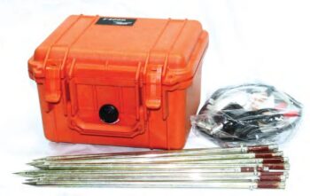
Cable: 2.5m point pitch, 10m line pitch 54.7m in total length
Electrode: Each comes standard with 22pcs
Host Weight: 1.95kg
PQWT-GT Auto-analysis Geophysical Detector is the eighth generation of multi-channel prospecting instrument newly developed by Hunan Puqi Geologic Exploration Equipment Institute and Hunan Puqi Water Environment Institute Co. Ltd.
It is based on the principle of natural electric field frequency selection method. It is widely used in underground water sources, geological structures, mine veins, mine tunnels, cavities, karst caves, ant holes, mined-out areas, dam pipe surge, landslides and other fields.
This series of instruments integrates 5 independent invention patents of PQWT, including data acquisition system, data processing system, automatic mapping system, automatic analysis system and circuit system.
It realizes the simultaneous data acquisition of multi-channel and multi-frequency, completely solves the influence of unstable factors caused by the time difference of the natural electric field source, and greatly improves the accuracy and work efficiency.
The instrument can process the collected data, automatically draw curve map, profile map, and 3D renderings in real time, and automatically analyze abnormal areas, to provide scientific basis for analyzing geological structures quickly and effectively.
Related Products
Depth 100 / 150 / 300 Meters
Frequency Single, Triple, 36/40/56frequency
Channel 8
System PQWT
LCD Industrial 7-inch HD touch screen
Units of Measurement △Vs(mV)
Measurement Range 0mV-2000mV
Stand-by Time 8-10 hours
Power Supply Battery Model #26650; 3.7V 4000mAh Rechargeable lithium battery
Depth: 400 Meters
Frequency: Single, Triple, 48frequency
Measurement data unit: electric field component of different frequencies of the earth electromagnetic field ΔVs (mV)
Channel: 8
System: PQWT
LCD: Industrial 7-inch HD touch screen
Units of Measurement: △Vs(mV)
Measurement Range: 0mV-1000mV
Display: LED indicator
A/D conversion: 8-bit 1Msps
Input impedance: ≥10MΩ
Relative humidity: ≤85%
Power consumption: about 1W
Working environment temperature: -20°C ~ +50°C
Power Supply: Battery Model #18650; 3000mAh Rechargeable lithium battery
Depth: 100m/150m/300m/500m
Measuring time: 8-10min
Measurement data unit electric field component of different frequencies of the earth electromagnetic field ΔVs (mV)
Maximum Channels: 18 channels
Display Screen: Industrial 10.1-inch HD touch screen.
A/D conversion: 16-bits 1Msps
Minimum resolution: 0.001mv
Point selection: 1-18 points optional.
Power consumption: about 9W
Working environment temperature: -20°C ~ +50°C
Controller: 32-bit high speed CPU
Standby time: 8h
Cable: 2.5m point pitch, 10m line pitch 54.7m in total length
Electrode: Each comes standard with 22pcs
Host Weight: 1.95kg
• Proton-precession sensor for absolute total-field measurements
• Rugged, weather-resistant housing for field durability
• Large, readable display with clear numeric and status indicators
• Onboard memory for thousands of readings and time-stamped records
• GPS time/position tagging (optional) and USB/Bluetooth data transfer
• Long-lasting rechargeable battery with field-replaceable pack
Lightweight carry case and mounted tripod/stand options
• High Sensitivity & Precision: Integrated digital sensors ensure accurate seismic signal detection.
• Wireless & Efficient: Cable-free design simplifies deployment and reduces operational costs.
• Durable Construction: IP-rated protection for use in rugged field conditions.
• Long Battery Life: Low power consumption for extended continuous recording.
• Flexible Applications: Ideal for 2D/3D seismic surveys, structural monitoring, and academic research.
• User-Friendly Software: Intuitive interface for setup, synchronization, and data retrieval.
• 8-channel simultaneous measurement for rapid data acquisition
• Wi-Fi enabled for seamless remote control and data transfer
• Expandable electrode capacity – supports up to 112 electrodes with 5m spacing
• Marine and land survey compatibility, ideal for complex terrains and aquatic environments
• Integrated GPS and EarthImager™ software for precise positioning and advanced inversion modeling
• Rugged field-ready design with heavy-duty transport case, stainless steel electrodes, and robust cabling
