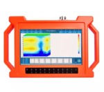


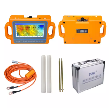
PQWT-M100
Product Features:
- No need to register
- No need network, no need traffic
- Automatically draw geological profile map
- Suitable for various terrain exploration
- Expert remote assistance to find location
- No experience person can operate in 5 minutes
- Two years warranty
Related Products

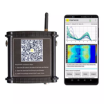
• Up to 12 measurement channels for simultaneous multi-electrode operations — enabling faster and richer data acquisition.
• Built-in electrode selector handling up to 81 electrodes, and with external selectors the system supports arrays in excess of 16,000 electrodes.
• Advanced IP mode with 100% duty cycle — significantly faster measurement and improved signal‐to‐noise ratio compared to conventional methods.
• Rugged housing (IEC IP66 rated) and design for field use in extreme temperatures (-20 °C to +70 °C) and harsh conditions.
• Fully embedded computing system with Wi-Fi, Ethernet, 3G/4G support, GPS/GLONASS, and removable storage for millions of readings — meaning you stay connected and in control.
• Scalable by software licensing — start with essential capabilities, then unlock more advanced features as your project demands grow.


Product Features:
- Be suitable for plain, hill, mountain land, highland, basin all kinds of geologic structure application;
- Automatic mapping in the instrument, get drilling position and depth result at site.
- Professional user group offers 24 hours after sale service.
- The average accuracy of more than 90% from user’s feedback.
- Four languages including English/Spanish/French/Arabic are optional.
- It is widely used for drinking water, agricultural irrigation water detection.
- Non-professionals can learn the operation way in 5 minutes.
- only 1-2 people can operate.
- Two years warranty.
- Selected the depth according to your demand, 100/150 / 300 Meters
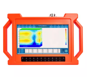
Product Features:
- Automatic analysis: The instrument analyzes the abnormal area with one click.
- Automatic mapping: Automatically draw curve map, profile map, and 3D renderings.
- Stable and reliable: Collect 18 points data with one-time wiring.
- Increment function: The extension of geological structure can be analyzed by making supplementary measurement in front and rear of the survey line.
- Data storage: It can store curve map, profile map, and 3D renderings of more than 999 survey lines to facilitate the production of geophysical exploration reports.


Product Features:
- Be suitable for plain, hill, mountain land, highland, basin all kinds of geologic structure application;
- Automatic mapping in the instrument, get drilling position and depth result at site.
- Professional user group offers 24 hours after sale service.
- The average accuracy of more than 90% from user’s feedback.
- Four languages including English/Spanish/French/Arabic are optional.
- It is widely used for drinking water, agricultural irrigation water detection.
- Non-professionals can learn the operation way in 5 minutes.
- only 1-2 people can operate.
- Two years warranty.
- Selected the depth according to your demand,150 / 300 / 500 / 600 Meters


Product Features:
- Be suitable for plain, hill, mountain land, highland, basin all kinds of geologic structure application;
- Automatic mapping in the instrument, get drilling position and depth result at site.
- Professional user group offers 24 hours after sale service.
- The average accuracy of more than 90% from user’s feedback.
- Four languages including English/Spanish/French/Arabic are optional.
- It is widely used for drinking water, agricultural irrigation water detection.
- Non-professionals can learn the operation way in 5 minutes.
- only 1-2 people can operate.
- Two years warranty.
- The models combines of 100M/ 150M


Product Features:
- Be suitable for plain, hill, mountain land, highland, basin all kinds of geologic structure application;
- Automatic mapping in the instrument, get drilling position and depth result at site.
- Professional user group offers 24 hours after sale service.
- The average accuracy of more than 90% from user’s feedback.
- Four languages including English/Spanish/French/Arabic are optional.
- It is widely used for drinking water, agricultural irrigation water detection.
- Non-professionals can learn the operation way in 5 minutes.
- only 1-2 people can operate.
- Two years warranty.
- Selected the depth according to your demand, 100/150 / 300 / 500 Meters