


PQWT-TC300
Multilingual support
Depth: 300 Meters
Frequency: Single, Triple, 40 Frequency
Channel: 6 Channels
Display: Industrial 7-Inch HD Touch screen
Measurement Range: 0mV – 1500Mv
Stand-by Time: 8-10 hours Power Supply: Battery Model #26650; 3.7V
4000mAh Rechargeable lithium battery
The PQWT-TC300 Automatic Mapping Water Detector is a high precision groundwater exploration instrument that uses the Earth’s natural electromagnetic field to analyze underground geological structures.
It automatically maps geological profiles in real time with one-click operation, eliminating complex computer processing. It is ideal for detecting aquifers, fractures and faults.
It performs efficiently across plains, hills, mountains, and basins. It is suitable for loating well positions and aquifer depths, boasting over 90% accuracy.
Related Products
Depth 100m/150m/300m
Measuring time 6-8min
Measurement data unit electric field component of different frequencies of the earth electromagnetic field ΔVs (mV)
Maximum Channels: 18
Display screen unit: 10.1-inch HD touch screen (1024 *600)
A/D conversion: 16-bits 1Msps
Minimum resolution: 0.001mv
Point selection: 1-18 points optional
Power consumption: about 9W
Working environment temperature: -20°C ~ +50°C
Controller : 32-bit high speed CPU
Standby time: 8h
Cable: 2.5m point pitch, 10m line pitch 54.7m in total length
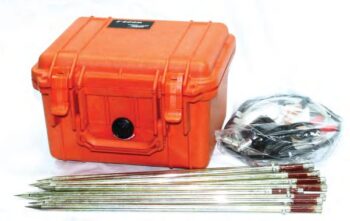
Electrode: Each comes standard with 22pcs
Host Weight: 1.95kg
• Dual Functionality: Measures both resistivity and induced polarization (IP) with exceptional precision.
• High Power & Depth: Advanced signal processing allows deep penetration and stable readings even in complex terrains.
• Intelligent Design: Automatic data recording, self-calibration, and real-time display simplify field operations.
• User-Friendly Interface: Intuitive touchscreen display and simple menu navigation enhance operational efficiency.
• Reliable Performance: Excellent anti-interference capability ensures accurate measurements in various geological environments.
• Flexible Data Management: Supports USB data export and PC software for data processing, mapping, and reporting.
• Multi-Channel Operation:
Supports simultaneous data acquisition from multiple electrodes, significantly improving survey speed and data accuracy.
• High Power Output:
Delivers strong current injection for deep detection and high-resistivity formations, ensuring reliable data even under challenging ground conditions.
• Intelligent Control System:
Features a microprocessor-based architecture with automatic ranging, polarity switching, and real-time monitoring for safe and efficient operation.
• High Precision Measurement:
Advanced digital filtering and noise reduction technology ensure stable, interference-free signals for accurate subsurface mapping.
• Flexible Configuration:
Compatible with multiple electrode arrays (Wenner, Schlumberger, Dipole-Dipole, etc.) for resistivity and induced polarization (IP) surveys.
• Durable Field Design:
Built with robust casing and weather-resistant components, making it ideal for both field and laboratory use.
• High Sensitivity & Precision: Integrated digital sensors ensure accurate seismic signal detection.
• Wireless & Efficient: Cable-free design simplifies deployment and reduces operational costs.
• Durable Construction: IP-rated protection for use in rugged field conditions.
• Long Battery Life: Low power consumption for extended continuous recording.
• Flexible Applications: Ideal for 2D/3D seismic surveys, structural monitoring, and academic research.
• User-Friendly Software: Intuitive interface for setup, synchronization, and data retrieval.
Depth 100 / 150 / 300 Meters
Frequency Single, Triple, 36/40/56frequency
Channel 8
System PQWT
LCD Industrial 7-inch HD touch screen
Units of Measurement △Vs(mV)
Measurement Range 0mV-2000mV
Stand-by Time 8-10 hours
Power Supply Battery Model #26650; 3.7V 4000mAh Rechargeable lithium battery

