-
Brand: GOLDDJ SERIES LOGGING WINCHRequest Quote
This is a high-performance cable deployment system designed to support borehole logging operations across hydrological, geological, and energy sectors.
It is built with advanced control systems and rugged mechanical integrity for smooth, accurate, and safe probe handling in demanding environments.Applications
Water well logging
Coal, oil, and gas exploration
Geothermal and mineral borehole surveys
Construction and geotechnical investigations. -
Brand: GOLDGD-1C Seismic NodeRequest Quote
Product Features:
• High Sensitivity & Precision: Integrated digital sensors ensure accurate seismic signal detection.
• Wireless & Efficient: Cable-free design simplifies deployment and reduces operational costs.
• Durable Construction: IP-rated protection for use in rugged field conditions.
• Long Battery Life: Low power consumption for extended continuous recording.
• Flexible Applications: Ideal for 2D/3D seismic surveys, structural monitoring, and academic research.
• User-Friendly Software: Intuitive interface for setup, synchronization, and data retrieval. -
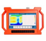
Brand: GOLDGD-5 Ultra Magnetotelluric SystemRequest Quote
Product Features
• Wideband Detection (DC–10 kHz): Delivers full-spectrum coverage for shallow and deep subsurface structures.
• High-Precision 32-bit ADC: Achieves crystal-clear signal fidelity with ultra-low noise and distortion.
• Multi-Mode Integration: Seamlessly supports MT, AMT, and CSAMT modes for flexible exploration needs.
• Real-Time Geological Imaging: View resistivity profiles, phase curves, and apparent resistivity instantly on-site.
• Rugged, Field-Ready Design: IP67-rated enclosure withstands harsh weather, dust, and impact.
• Ultra-Low Power Consumption (< 5 W): Ideal for extended field campaigns with minimal energy use.
• Precise Timing Synchronization (≤ 30 ns): Dual GPS and thermostatic crystal clock ensure timing integrity in all conditions.
• High Data Capacity & Fast Transfer: Built-in 64 GB storage with USB, WiFi, and Ethernet connectivity. -
Brand: GOLDGD-C1201 FULL HOLE IMAGING SYSTEM GRAPHRequest Quote
This is a borehole visualization solution designed to capture 360 degrees high-resolution images of borehole walls in real time.
Whether for geological mapping, structural analysis, or fracture identification, it delivers unmatched clarity and spatial accuracy.Applications
Geologic core replacement and structural logging
Fracture and fault zone identification
Lithology and stratigraphy analysis
Geotechnical and civil engineering assessments
Mining and hydrogeological investigations. -
Brand: GOLDGDP-3D WIRELESS DIGITAL INCLINOMETERRequest Quote
This is a borehole survey instrument designed for high -precision measurement of inclination (dip) and azimuth in vertical and directional drilling.
It integrates advanced wireless communication, 3-axis magnetometers, and accelerometers to deliver fast, accurate, and inference resistant data.Key Features
Wireless and Bluetooth connectivity – enables seamless data transmission and real-time monitoring without cumbersome cables, enhancing field efficiency and safety.
3D orientation sensing – equipped with three magnetometers and three accelerometers for full spatial awareness and high-resolution directional data.
Magnetic multi-shot surveying – captures multiple orientation points in a single run, ideal for complex borehole trajectories.
High precision and stability – it is engineered for consistent performance in non-magnetic and weak magnetic formations, minimizing distortion and drift.
Portable and user-friendly – It has a compact design and an intuitive interface suitable for varied field conditions and rapid deployment. -
Brand: GOLDGDQ-2D DIGITAL INCLINOMETERRequest Quote
This is a compact, high precision instrument designed to measure borehole inclination (vertex) and azimuth in geological drilling environments.
It delivers reliable orientation data critical for directional control, structural mapping, and resource targeting
-
Brand: GOLDGDQ-2D GEOPHYSICAL BOREHOLE LOGGING EQUIPMENTRequest Quote
This is cutting-edge borehole logging equipment designed to meet the demands of modern subsurface exploration and engineering.
Applications:
Hydrological water well logging
Coal well logging
Oil and Gas well logging
Geothermal well logging
Solid metal ore well logging
Construction engineering well logging
Other well logging -
Brand: GOLDGYGD-IV Rotary Borehole Inspection CamerasRequest Quote
GYGD-IV 360 Rotary Borehole Inspection Camera is a new model deep well camera with a 12-inch screen, 32G USB storage and keyboard input. This borehole camera can see both down view and lateral view at same time. It is integrated with the functions of borehole photographing, video recording and text input. It can be used to obtain borehole dynamic video and high-definition photos simultaneously, and it also has 8 times digital magnification function. It uses a low power embedded dual core processor. The camera system includes a monitor, an electrical winch, and a downhole camera probe. Available in 300M, 400M, 500M, 600M, 800M, 1000M
Technical Sheet
1. Imaging Chip: 1/3” color CCD, sensitivity 0.1Lux.
2. Display: LCD, 12 inches, resolution 1024*768.
3. Lens: Manually fine-tune the focus; the lens is 360 degrees horizontally, tilted 180 degrees to rotate, freely controlled and can stay in any position.
4. Illumination Unit: front LED patch lamp beads, the brightness of the light source is adjustable in 8 levels.
Measurement Depth: 300M, 400M, 500M, 600M, 800M, 1000M
5. Storage Unit: U Disk.
6. Probe: Panorama/ rotation can be replaced at will, 40-120mm.
7. Working Voltage: AC 220V50Hz.
8. The tensile strength of the cable is 250kg.
9. The maximum pressure of the probe is not less than 15Mpa. -
Brand: GOLDGYGD-V PUSH ROD INSPECTION CAMERARequest Quote
This is a portable solution for visual inspection of pipelines, boreholes, and confined spaces.
It offers real time diagnostics in water supply, drainage, construction, and geotechnical applications.Applications
Municipal water and sewer line inspection
Construction site pipe integrity checks
Borehole and tunnel visual surveys
Industrial pipe maintenance
Environmental and geotechnical investigations. -
Brand: GOLDJTG-1 FIBER OPTIC NORTH-FINDER GYRO INCLINOMETERRequest Quote
The Fiber-Optic North Finder Gyro Inclinometer is a non-magnetic borehole survey instrument ideal for accurate azimuth and inclination measurements in environments where magnetic interference is a major concern.
It is powered by advanced fiber-optic gyroscope (FOG) technology. It ensures reliable orientation data in iron casing wells, deep boreholes, and complex geological settings.Applications
Mineral exploration and resource delineation
Oil, gas, and geothermal directional drilling
Geotechnical and civil engineering surveys
Tunnel and underground infrastructure monitoring, -
Brand: GOLDWCZ Proton MagnetometerRequest Quote
Product Features:
• Proton-precession sensor for absolute total-field measurements
• Rugged, weather-resistant housing for field durability
• Large, readable display with clear numeric and status indicators
• Onboard memory for thousands of readings and time-stamped records
• GPS time/position tagging (optional) and USB/Bluetooth data transfer
• Long-lasting rechargeable battery with field-replaceable pack
Lightweight carry case and mounted tripod/stand options -
Brand: GOLDWDA-1 Super Digital Resistivity MeterRequest Quote
Product Features:
• Dual Functionality: Measures both resistivity and induced polarization (IP) with exceptional precision.
• High Power & Depth: Advanced signal processing allows deep penetration and stable readings even in complex terrains.
• Intelligent Design: Automatic data recording, self-calibration, and real-time display simplify field operations.
• User-Friendly Interface: Intuitive touchscreen display and simple menu navigation enhance operational efficiency.
• Reliable Performance: Excellent anti-interference capability ensures accurate measurements in various geological environments.
• Flexible Data Management: Supports USB data export and PC software for data processing, mapping, and reporting. -
Brand: GOLDWDDS-3 Digital Resistivity MeterRequest Quote
Product Features:
• High Measurement Accuracy: It delivers reliable resistivity readings with excellent anti-interference performance, even in complex geological conditions.
• Automatic Data Processing: It is integrated with intelligent system for real-time data analysis, curve plotting, and geological profiling without the need for external computers.
• User-Friendly Operation: It has one-touch control and clear LCD interface simplify field operations, reducing survey time and improving productivity.
• Powerful Performance: It is capable of high-voltage and long-distance measurements, enabling deep exploration up to several hundred meters.
• Durable & Portable Design: Rugged construction and compact build for easy transport and dependable use in diverse environments. -
Brand: GOLDWDFZ-9 Super Electric Multi-electrode Survey SystemRequest Quote
• Multi-Channel Operation:
Supports simultaneous data acquisition from multiple electrodes, significantly improving survey speed and data accuracy.
• High Power Output:
Delivers strong current injection for deep detection and high-resistivity formations, ensuring reliable data even under challenging ground conditions.
• Intelligent Control System:
Features a microprocessor-based architecture with automatic ranging, polarity switching, and real-time monitoring for safe and efficient operation.
• High Precision Measurement:
Advanced digital filtering and noise reduction technology ensure stable, interference-free signals for accurate subsurface mapping.
• Flexible Configuration:
Compatible with multiple electrode arrays (Wenner, Schlumberger, Dipole-Dipole, etc.) for resistivity and induced polarization (IP) surveys.
• Durable Field Design:
Built with robust casing and weather-resistant components, making it ideal for both field and laboratory use. -
Brand: GOLDWTEM Transient Electromagnetic SystemRequest Quote
Product Features:
High-Power Transmission & Fast Shutdown
WTEM’s robust transmitter delivers large power output and a rapid shutdown mechanism that extends detection range and improves resolution, especially in shallow surveys.
Superior Anti-Interference Capability
Built to withstand electrical noise such as atmospheric interference and 50/60 Hz industrial signals, the WTEM system ensures high-quality data in even the most challenging environments.Versatile Configuration
The WTEM receiver pairs with either high-power transmitters for deep exploration or smaller transmitters for shallow investigations, giving you flexible deployment across project types.
Advanced Synchronization
Support for multiple synchronization modes — including cable and GPS synchronization — ensures precise timing and stable data acquisition across survey sites.
Lightweight & Efficient
Designed with portability and low power consumption in mind, the WTEM system performs reliably in the field while minimizing logistical complexity.
User-Friendly Interface
An intuitive control interface simplifies setup and data collection, while integrated software tools support real-time monitoring and post-survey analysis.