


PQWT-TC300
Multilingual support
Depth: 300 Meters
Frequency: Single, Triple, 40 Frequency
Channel: 6 Channels
Display: Industrial 7-Inch HD Touch screen
Measurement Range: 0mV – 1500Mv
Stand-by Time: 8-10 hours Power Supply: Battery Model #26650; 3.7V
4000mAh Rechargeable lithium battery
The PQWT-TC300 Automatic Mapping Water Detector is a high precision groundwater exploration instrument that uses the Earth’s natural electromagnetic field to analyze underground geological structures.
It automatically maps geological profiles in real time with one-click operation, eliminating complex computer processing. It is ideal for detecting aquifers, fractures and faults.
It performs efficiently across plains, hills, mountains, and basins. It is suitable for loating well positions and aquifer depths, boasting over 90% accuracy.
Related Products
Depth: 400 Meters
Frequency: Single, Triple, 48frequency
Measurement data unit: electric field component of different frequencies of the earth electromagnetic field ΔVs (mV)
Channel: 8
System: PQWT
LCD: Industrial 7-inch HD touch screen
Units of Measurement: △Vs(mV)
Measurement Range: 0mV-1000mV
Display: LED indicator
A/D conversion: 8-bit 1Msps
Input impedance: ≥10MΩ
Relative humidity: ≤85%
Power consumption: about 1W
Working environment temperature: -20°C ~ +50°C
Power Supply: Battery Model #18650; 3000mAh Rechargeable lithium battery
• 8-channel simultaneous measurement for rapid data acquisition
• Wi-Fi enabled for seamless remote control and data transfer
• Expandable electrode capacity – supports up to 112 electrodes with 5m spacing
• Marine and land survey compatibility, ideal for complex terrains and aquatic environments
• Integrated GPS and EarthImager™ software for precise positioning and advanced inversion modeling
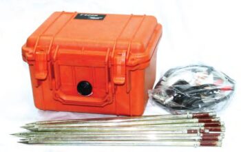
• Rugged field-ready design with heavy-duty transport case, stainless steel electrodes, and robust cabling
Accurate Depth Measurement: Provides quick and precise readings of water depth with a standard resolution of 0.5 mm.
Audible Signal: Emits a clear tone when the probe contacts water, making detection easy even in noisy environments.
Durable Tape: Uses a flat, high-tensile, non-stretch tape with clear depth markings for long-term reliability.
Battery Operated: Lightweight and portable, ideal for field use without the need for external power.
Multiple Length Options: Available in lengths ranging from 100 meters to 1000 meters, suitable for shallow and deep wells
Depth 100 / 150 / 300 Meters
Frequency Single, Triple, 36/40/56frequency
Channel 8
System PQWT
LCD Industrial 7-inch HD touch screen
Units of Measurement △Vs(mV)
Measurement Range 0mV-2000mV
Stand-by Time 8-10 hours
Power Supply Battery Model #26650; 3.7V 4000mAh Rechargeable lithium battery
• Proton-precession sensor for absolute total-field measurements
• Rugged, weather-resistant housing for field durability
• Large, readable display with clear numeric and status indicators
• Onboard memory for thousands of readings and time-stamped records
• GPS time/position tagging (optional) and USB/Bluetooth data transfer
• Long-lasting rechargeable battery with field-replaceable pack
Lightweight carry case and mounted tripod/stand options
High-Power Transmission & Fast Shutdown
WTEM’s robust transmitter delivers large power output and a rapid shutdown mechanism that extends detection range and improves resolution, especially in shallow surveys.
Superior Anti-Interference Capability
Built to withstand electrical noise such as atmospheric interference and 50/60 Hz industrial signals, the WTEM system ensures high-quality data in even the most challenging environments.
Versatile Configuration
The WTEM receiver pairs with either high-power transmitters for deep exploration or smaller transmitters for shallow investigations, giving you flexible deployment across project types.
Advanced Synchronization
Support for multiple synchronization modes — including cable and GPS synchronization — ensures precise timing and stable data acquisition across survey sites.
Lightweight & Efficient
Designed with portability and low power consumption in mind, the WTEM system performs reliably in the field while minimizing logistical complexity.
User-Friendly Interface
An intuitive control interface simplifies setup and data collection, while integrated software tools support real-time monitoring and post-survey analysis.
• Dual Functionality: Measures both resistivity and induced polarization (IP) with exceptional precision.
• High Power & Depth: Advanced signal processing allows deep penetration and stable readings even in complex terrains.
• Intelligent Design: Automatic data recording, self-calibration, and real-time display simplify field operations.
• User-Friendly Interface: Intuitive touchscreen display and simple menu navigation enhance operational efficiency.
• Reliable Performance: Excellent anti-interference capability ensures accurate measurements in various geological environments.
• Flexible Data Management: Supports USB data export and PC software for data processing, mapping, and reporting.
