


WTEM Transient Electromagnetic System
High-Power Transmission & Fast Shutdown
WTEM’s robust transmitter delivers large power output and a rapid shutdown mechanism that extends detection range and improves resolution, especially in shallow surveys.
Superior Anti-Interference Capability
Built to withstand electrical noise such as atmospheric interference and 50/60 Hz industrial signals, the WTEM system ensures high-quality data in even the most challenging environments.
Versatile Configuration
The WTEM receiver pairs with either high-power transmitters for deep exploration or smaller transmitters for shallow investigations, giving you flexible deployment across project types.
Advanced Synchronization
Support for multiple synchronization modes — including cable and GPS synchronization — ensures precise timing and stable data acquisition across survey sites.
Lightweight & Efficient
Designed with portability and low power consumption in mind, the WTEM system performs reliably in the field while minimizing logistical complexity.
User-Friendly Interface
An intuitive control interface simplifies setup and data collection, while integrated software tools support real-time monitoring and post-survey analysis.
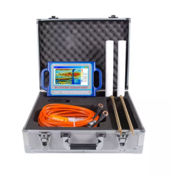
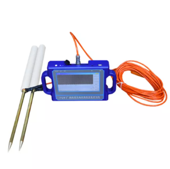
The WTEM Transient Electromagnetic Method System is an advanced geophysical exploration solution engineered for rapid, high-precision subsurface investigation. Designed to integrate the best features of transient electromagnetic (TEM) technology from around the world, the WTEM system delivers powerful transmission, exceptional anti-interference performance, and reliable data quality in diverse field conditions — from shallow environmental mapping to deep mineral and groundwater exploration.
Typical Applications
The WTEM Transient Electromagnetic Method System is ideal for a wide range of geological and engineering exploration tasks, including:
• Mineral exploration (e.g., base metals, gold deposits)
• Groundwater and aquifer mapping
• Environmental and engineering geophysics
• Hydrocarbon and geothermal reconnaissance
• Railway and infrastructure subsurface surveys
Related Products
Multilingual support
Depth: 300 Meters
Frequency: Single, Triple, 40 Frequency
Channel: 6 Channels
Display: Industrial 7-Inch HD Touch screen
Measurement Range: 0mV – 1500Mv
Stand-by Time: 8-10 hours Power Supply: Battery Model #26650; 3.7V
4000mAh Rechargeable lithium battery
• Multi-Channel Operation:
Supports simultaneous data acquisition from multiple electrodes, significantly improving survey speed and data accuracy.
• High Power Output:
Delivers strong current injection for deep detection and high-resistivity formations, ensuring reliable data even under challenging ground conditions.
• Intelligent Control System:
Features a microprocessor-based architecture with automatic ranging, polarity switching, and real-time monitoring for safe and efficient operation.
• High Precision Measurement:
Advanced digital filtering and noise reduction technology ensure stable, interference-free signals for accurate subsurface mapping.
• Flexible Configuration:
Compatible with multiple electrode arrays (Wenner, Schlumberger, Dipole-Dipole, etc.) for resistivity and induced polarization (IP) surveys.
• Durable Field Design:
Built with robust casing and weather-resistant components, making it ideal for both field and laboratory use.
Depth 100 / 150 / 300 / 500 Meters
Frequency Single, Triple, 36/40/56frequency
Channel 8
System PQWT
LCD Industrial 7-inch HD touch screen
Units of Measurement △Vs(mV)
Measurement Range 0mV-2000mV
Stand-by Time 8-10 hours
Power Supply Battery Model #26650; 3.7V 4000mAh Rechargeable lithium battery
• Proton-precession sensor for absolute total-field measurements
• Rugged, weather-resistant housing for field durability
• Large, readable display with clear numeric and status indicators
• Onboard memory for thousands of readings and time-stamped records
• GPS time/position tagging (optional) and USB/Bluetooth data transfer
• Long-lasting rechargeable battery with field-replaceable pack
Lightweight carry case and mounted tripod/stand options
• 8-channel simultaneous measurement for rapid data acquisition
• Wi-Fi enabled for seamless remote control and data transfer
• Expandable electrode capacity – supports up to 112 electrodes with 5m spacing
• Marine and land survey compatibility, ideal for complex terrains and aquatic environments
• Integrated GPS and EarthImager™ software for precise positioning and advanced inversion modeling
• Rugged field-ready design with heavy-duty transport case, stainless steel electrodes, and robust cabling
Depth 200 Meters
Frequency Single, Triple, 36frequency
Measurement data unit electric field component of different frequencies of the earth electromagnetic field ΔVs (mV)
Channel 6
System PQWT
Units of Measurement △Vs(mV)
Measurement Range 0mV-1500mV
Display LED indicator
A/D conversion 8-bit 1Msps
Input impedance ≥10MΩ
Relative humidity ≤85%
Power consumption about 1W
Working environment temperature -20°C ~ +50°C
Power Supply Battery Model #18650; 3000mAh Rechargeable lithium battery
• Wideband Detection (DC–10 kHz): Delivers full-spectrum coverage for shallow and deep subsurface structures.
• High-Precision 32-bit ADC: Achieves crystal-clear signal fidelity with ultra-low noise and distortion.
• Multi-Mode Integration: Seamlessly supports MT, AMT, and CSAMT modes for flexible exploration needs.
• Real-Time Geological Imaging: View resistivity profiles, phase curves, and apparent resistivity instantly on-site.
• Rugged, Field-Ready Design: IP67-rated enclosure withstands harsh weather, dust, and impact.
• Ultra-Low Power Consumption (< 5 W): Ideal for extended field campaigns with minimal energy use.
• Precise Timing Synchronization (≤ 30 ns): Dual GPS and thermostatic crystal clock ensure timing integrity in all conditions.
• High Data Capacity & Fast Transfer: Built-in 64 GB storage with USB, WiFi, and Ethernet connectivity.
