


GD-5 Ultra Magnetotelluric System
• Wideband Detection (DC–10 kHz): Delivers full-spectrum coverage for shallow and deep subsurface structures.
• High-Precision 32-bit ADC: Achieves crystal-clear signal fidelity with ultra-low noise and distortion.
• Multi-Mode Integration: Seamlessly supports MT, AMT, and CSAMT modes for flexible exploration needs.
• Real-Time Geological Imaging: View resistivity profiles, phase curves, and apparent resistivity instantly on-site.
• Rugged, Field-Ready Design: IP67-rated enclosure withstands harsh weather, dust, and impact.
• Ultra-Low Power Consumption (< 5 W): Ideal for extended field campaigns with minimal energy use.
• Precise Timing Synchronization (≤ 30 ns): Dual GPS and thermostatic crystal clock ensure timing integrity in all conditions.
• High Data Capacity & Fast Transfer: Built-in 64 GB storage with USB, WiFi, and Ethernet connectivity.
The GD-5 Ultra Magnetotelluric System is built for deep geological, mineral, geothermal, and groundwater surveys, this powerful system integrates MT, AMT, and CSAMT methods in a single compact platform.
Built on advanced digital architecture, the GD-5 Ultra features six synchronized channels (three electric and three magnetic) for simultaneous broadband data acquisition.
Its wide frequency range (DC–10 kHz) and 32-bit high-speed sampling ensure exceptional resolution from shallow to ultra-deep layers of the Earth’s crust.
With real-time imaging, ultra-low noise design, and GPS-based nanosecond synchronization, every measurement captured is precise and ready for immediate interpretation even in the most remote field environments.
Applications
• Mineral and Metal Exploration – Detect conductive ore bodies, faults, and mineralized zones.
• Geothermal Resource Assessment – Identify reservoirs, caprock, and hydrothermal structures.
• Groundwater Detection – Map aquifers, salinity boundaries, and recharge zones.
• Oil & Gas Exploration – Characterize deep structures and fluid migration pathways.
• Engineering & Tunnel Surveys – Assess geological stability before excavation.
• Scientific Research – Study crustal conductivity, fault zones, and tectonic structures.
Related Products
High-Power Transmission & Fast Shutdown
WTEM’s robust transmitter delivers large power output and a rapid shutdown mechanism that extends detection range and improves resolution, especially in shallow surveys.
Superior Anti-Interference Capability
Built to withstand electrical noise such as atmospheric interference and 50/60 Hz industrial signals, the WTEM system ensures high-quality data in even the most challenging environments.
Versatile Configuration
The WTEM receiver pairs with either high-power transmitters for deep exploration or smaller transmitters for shallow investigations, giving you flexible deployment across project types.
Advanced Synchronization
Support for multiple synchronization modes — including cable and GPS synchronization — ensures precise timing and stable data acquisition across survey sites.
Lightweight & Efficient
Designed with portability and low power consumption in mind, the WTEM system performs reliably in the field while minimizing logistical complexity.
User-Friendly Interface
An intuitive control interface simplifies setup and data collection, while integrated software tools support real-time monitoring and post-survey analysis.
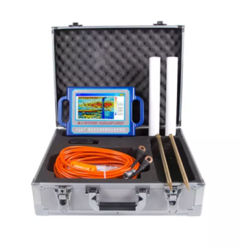
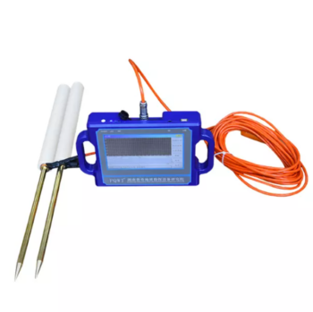
• High Measurement Accuracy: It delivers reliable resistivity readings with excellent anti-interference performance, even in complex geological conditions.
• Automatic Data Processing: It is integrated with intelligent system for real-time data analysis, curve plotting, and geological profiling without the need for external computers.
• User-Friendly Operation: It has one-touch control and clear LCD interface simplify field operations, reducing survey time and improving productivity.
• Powerful Performance: It is capable of high-voltage and long-distance measurements, enabling deep exploration up to several hundred meters.
• Durable & Portable Design: Rugged construction and compact build for easy transport and dependable use in diverse environments.
Depth: 400 Meters
Frequency: Single, Triple, 48frequency
Measurement data unit: electric field component of different frequencies of the earth electromagnetic field ΔVs (mV)
Channel: 8
System: PQWT
LCD: Industrial 7-inch HD touch screen
Units of Measurement: △Vs(mV)
Measurement Range: 0mV-1000mV
Display: LED indicator
A/D conversion: 8-bit 1Msps
Input impedance: ≥10MΩ
Relative humidity: ≤85%
Power consumption: about 1W
Working environment temperature: -20°C ~ +50°C
Power Supply: Battery Model #18650; 3000mAh Rechargeable lithium battery
Depth 100 / 150 / 300 / 500 Meters
Frequency Single, Triple, 36/40/56frequency
Channel 8
System PQWT
LCD Industrial 7-inch HD touch screen
Units of Measurement △Vs(mV)
Measurement Range 0mV-2000mV
Stand-by Time 8-10 hours
Power Supply Battery Model #26650; 3.7V 4000mAh Rechargeable lithium battery
Depth: 100m/150m/300m/500m
Measuring time: 8-10min
Measurement data unit electric field component of different frequencies of the earth electromagnetic field ΔVs (mV)
Maximum Channels: 18 channels
Display Screen: Industrial 10.1-inch HD touch screen.
A/D conversion: 16-bits 1Msps
Minimum resolution: 0.001mv
Point selection: 1-18 points optional.
Power consumption: about 9W
Working environment temperature: -20°C ~ +50°C
Controller: 32-bit high speed CPU
Standby time: 8h
Cable: 2.5m point pitch, 10m line pitch 54.7m in total length
Electrode: Each comes standard with 22pcs
Host Weight: 1.95kg

Depth 100 / 150 / 300 Meters
Frequency Single, Triple, 36/40/56frequency
Channel 8
System PQWT
LCD Industrial 7-inch HD touch screen
Units of Measurement △Vs(mV)
Measurement Range 0mV-2000mV
Stand-by Time 8-10 hours
Power Supply Battery Model #26650; 3.7V 4000mAh Rechargeable lithium battery
